


boucle la goûterez boulouneix

fab0202
User
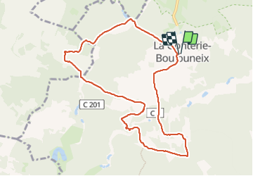

Length
10.2 km

Max alt
198 m

Uphill gradient
242 m
Km-Effort
13.4 km

Min alt
120 m

Downhill gradient
241 m
Boucle
Yes
Creation date :
2023-10-08 06:39:02.988
Updated on :
2023-10-08 10:12:55.703
3h11
Difficulty : Easy

FREE GPS app for hiking
 SityTrail
IGN / Geographical institutes
SityTrail Plus
The world is yours!
About
Trail Walking of 10.2 km to be discovered at New Aquitaine, Dordogne, Brantôme en Périgord. This trail is proposed by fab0202.
Description
belle rando entre bois et campagne
Positioning
Country:
France
Region :
New Aquitaine
Department/Province :
Dordogne
Municipality :
Brantôme en Périgord
Location:
Unknown
Start:(Dec)
Start:(UTM)
311268 ; 5028877 (31T) N.
Comments